
Mapping and Data Services
Photogrammetry, GIS and Lidar Data Processing
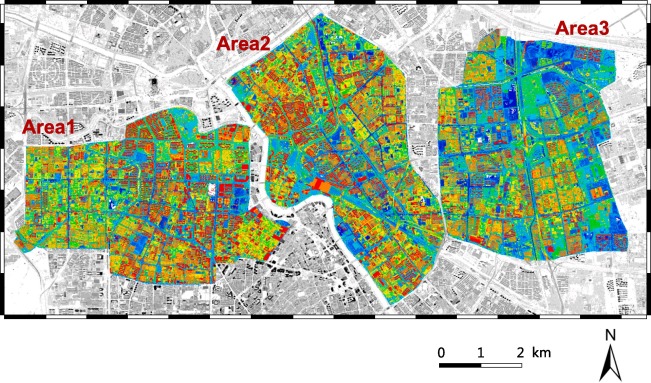
Halkin Inc. has completed several geospatial and GIS projects in the United States and internationally. In the U.S., our work includes 4-lane road widening projects across multiple counties in California, Lidar-based road safety assessments for various states, and numerous GIS mapping initiatives. Internationally, we have delivered extensive photogrammetry and cartography projects in the Kingdom of the USA. Projects were completed at various scales, including 1:1,000, 1:2,500, and 1:10,000.
Halkin Inc. also brings deep expertise in GIS, including data editing, spatial analysis, and 3D fly-throughs using tools like ArcGIS and QGIS. We handle a variety of geographic data types—vector (points, lines, polygons), raster (imagery), and tabular data. We create detailed, informative maps for applications in environmental science, urban planning, transportation, and more. Our GIS professionals have served in roles such as GIS Technician, Analyst, and Specialist, ensuring flexible, industry-specific experties.
Our Application
Our Mapping and Data Services provide high-accuracy geospatial data for design, planning, and asset management. Using aerial imagery, Lidar, and photogrammetry, we deliver survey-grade precision.

As-Built CAD/BIM Integration
Seamless delivery of data compatible with AutoCAD, Revit, and MicroStation.

Resolution Maps & Orthomosaics
Generate centimeter-level accurate maps for construction and engineering.
Change Detection
Detect site variations within 2 cm using time-series analysis and point cloud comparisons.
Our Partnership
Halkin Inc. is now an official Partner with Khalid Al Raddadi Surveying
Drone Lidar Survey & Mapping
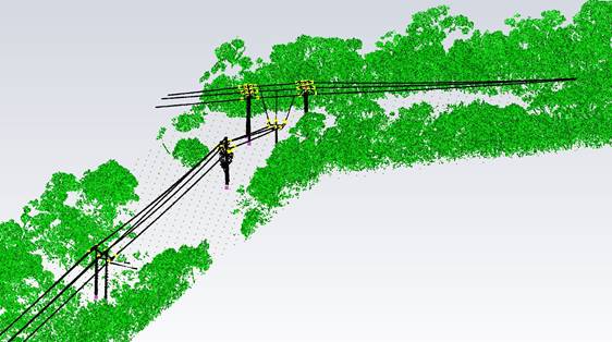
Lidar (Light Detection and Ranging) is an advanced surveying method that uses laser pulses to measure distances with exceptional accuracy. A laser beam is emitted and reflected off surrounding objects, and by calculating the time it takes to return to the sensor, precise distance measurements are obtained. When thousands of these laser pulses are captured every second, they form a dense and highly detailed 3D point cloud of the environment.
Halkin Inc. offers a clear comparison between drone-based Lidar surveys and traditional photogrammetric mapping. Drone-mounted Lidar systems provide highly accurate data, particularly in areas with dense vegetation or complex terrain. However, Lidar surveys generally come at a higher cost compared to photogrammetry, largely due to the specialized sensors and advanced drone platforms required to operate them.
A wide range of Lidar sensors is available in the market, each at different price points—and these variations can significantly influence the accuracy and quality of the final dataset.
Lidar truly excels in environments with dense vegetation. Unlike photogrammetry, which relies on visual imagery, Lidar’s laser pulses can penetrate through foliage and reach the ground, producing more reliable elevation data and terrain models in heavily covered areas.
For more information about asset inspection in your area of interest, explore the industries we serve or reach out to us directly to discuss how we can support your project.
Uses of Lidar Includes
Covering large areas where the data is needed quickly after capture.
Survey of Catenary analysis of conductors under dense vegetation.
Identifying and inspecting vegetation encroachment into powerline corridors .
Survey of all types of lands under dense vegetation using special drones.
Assisting in the 3D modelling of complex or shiny structures for better visuals.
Reach out to get our services
From materials inspection to scale rendered mapping and land analysis, Halkin’s certified technicians and software engineers provide customers with concise and expedient reporting and training through a conjunct GIS software platform.